
Geology of Afar Depression (non-technical)
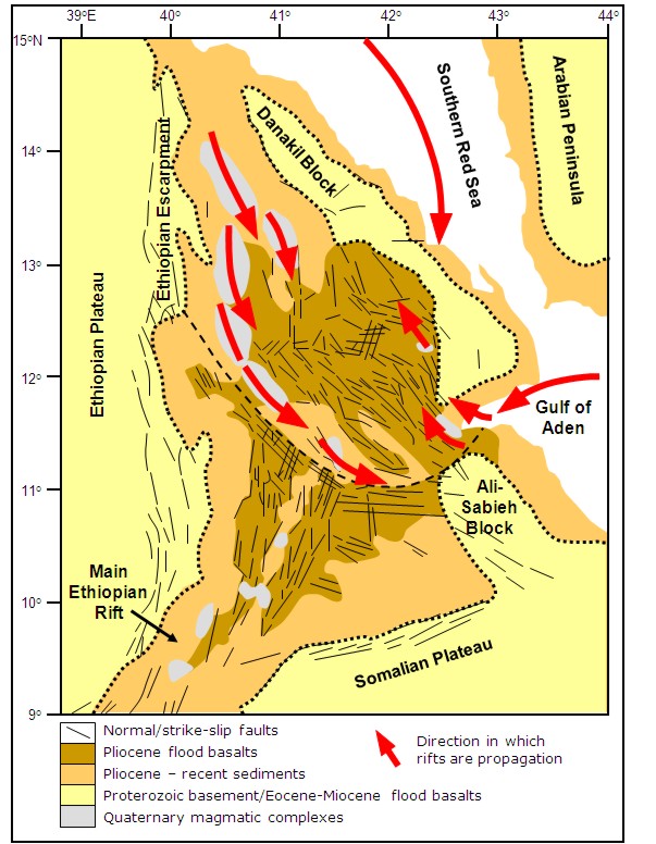
Figure 1: Geological map of Afar showing fault orientations and distribution of the magmatic segments. The red arrows show the direction in which the rifts are propagating. After Barberi & Varet, 1977; Hayward & Ebinger, 1996; Hofstetter & Beyth, 2003 and Rowland et al, 2007.
Geology of the Afar Depression
The Afar Depression is an area of lowland plains dotted with shield volcanoes. It is cut by faults which separate areas of higher ground (or fault blocks) from the rest of the plain. It is bound to the west by the Ethiopian Plateau and escarpment, to the northeast by the Danakil block, to the southeast by the Ali-Sabieh block and to the south by the Somalian Plateau and escarpment. To the north the southern Red Sea rift is extending down through the Gulf of Zula into the northern Afar Depression, to the east the Gulf of Aden rift is spreading through the Gulf of Tajura into the eastern Afar Depression and to the southwest extension continues through the Main Ethiopian Rift to the East African Rift System Figure 1.
Along the edges of the Afar Depression are large faults up to 60km long. These developed during the Oligo-Miocene (29-26 million years ago) as the Earth’s crust in the region began to be pulled apart by the movement of the plates. The faults led to the centre of the Depression dropping down relative to the Ethiopian and Somalian Plateaux and the formation of the rift valley. The area is now close to or, in parts, below sea level.
Between about 16 and 7 million years ago, as the plates continued to separate and extension increased across the region, magma from deep in the Earth rose through the crust warming and weakening it. Movement on the border faults ceased, although they still command the landscape, and smaller faults developed along narrow bands in the centre of the rift valley. These narrow bands have continued to develop with thin vertical sheets of magma (dykes) being injected along them and erupting at the surface as volcanoes.
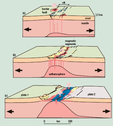
Figure 2: The stages in the development of a volcanic passive margin based on studies of the East African Rift system (Ebinger, 2005).
These areas of faults and dykes in the centre of the rift valley are known as known as magmatic segments and are very similar to the types of structures seen along sea-floor spreading centres Figure 2.
Based on the orientation of the faults, the Afar Depression can be divided into three regions: northern, east-central and southern.
For references used, please see technical version.