
Geology of Danakil and Ali-Sabieh Blocks
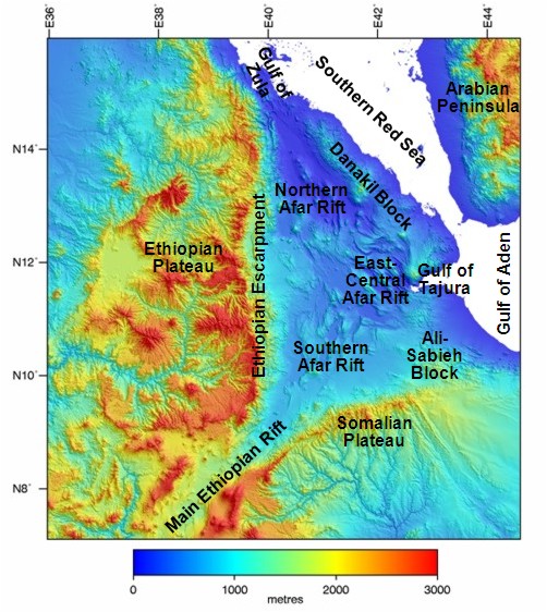
Digital elevation map of the Afar region showing the main structural divisions.
Geology of the Danakil and Ali-Sabieh Blocks
Danakil Block
On the eastern edge of the Afar Depression and separating it from the southern Red Sea is the narrow, northwest-trending Danakil horst or microplate. It is a ridge about 500km long, 100km wide and on average 400m high of Precambrian basement overlain by Oligocene to recent lavas from the Afar flood basalt province. Originally, the Danakil block lay against the Ethiopian plateau on the western Afar margin but about 20Ma as the Somalian, Arabian and Nubian plates began to rift apart it broke away from the Plateau. It has continued to move to the east/northeast relative to the Plateau as the Afar rift zone has opened up (Makris & Ginzburg, 1987; Beyth, 1991; Makris et al, 1991, Manighetti et al, 2001, Eagles et al, 2002, Beyene & Abdelsalam, 2005 and refs therein). To the south of the Danakil block is the Asal-Ghoubbet rift along which the Gulf of Aden rift is propagating into the Afar region. If this along axis propagation from the Gulf of Aden continues the Danakil block will become a microplate connected to the Arabian plate but surrounded by oceanic crust (Eagles et al, 2002).
Ali-Sabieh Block
The Ali-Sabieh Block (aka Aysha’z, Aysha or Ali Savieh block) extends northwards from the Somalian Plateau. Prior to the propagation of the Gulf of Aden through the Gulf of Tajura and Asal-Ghoubbet rift this area was continuous with the Danakil block (Beyene & Abdelsalam, 2005). It has a lower elevation than the Somalian Plateau and is a strongly attenuated continental block that has remained attached to the Somalian plate during rifting. The block is believed to have rotated 90o clockwise over the last 20 Ma during the opening of the Afar Depression. Evidence for this comes from the spatter cones along north-south trending sinistral strike-slip faults along the western edge of the block (Christiansen et al, 1975; Manighetti et al, 2001).