
Wright et al 2012
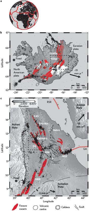
Figure 1: Location of subaerial spreading centres. a, Overview map showing plate boundaries. b, Tectonic map of Iceland. Black dots are earthquakes. Ice caps are indicated in white. c, Tectonic map of the Afar region. 'Magmatic segments' re-plotted in a consistent style with the Icelandic 'fissure swarms'. AGS, Asal-Ghoubbet spreading centre; DS, Dabbahu spreading centre; EAS, Erta Ale spreading centre; RSR, Red Sea rift; GA, Gulf of Aden; MER, Main Ethiopian Rift.
Geophysical constraints on the dynamics of spreading centres from rifting episodes on land by T.Wright et al, 2012
Non-technical summary
Most of the Earth's crust is created along 60,000 km of mid-ocean ridge system. Here, tectonic plates spread apart and, in doing so, gradually build up stress. This stress is released during rifting episodes, when bursts of magmatic activity lead to the injection of vertical sheets of magma — termed dykes — into the crust.
Only 2% of the global mid-ocean ridge system is above sea level, so making direct observations of the rifting process is difficult. However, geodetic and seismic observations exist from spreading centres in Afar (East Africa) and Iceland that are exposed at the land surface.
Rifting episodes are rare, but the few that have been well observed at these sites have operated with remarkably similar mechanisms. Specifically, magma is supplied to the crust in an intermittent manner, and is stored at multiple positions and depths. It then laterally intrudes in dykes within the brittle upper crust. Depending on the availability of magma, multiple magma centres can interact during one rifting episode.
If large eruptions at spreading centres are to be forecast then rifting-cycle models will need to fully incorporate realistic crust and mantle properties, as well as the dynamic transport of magma.
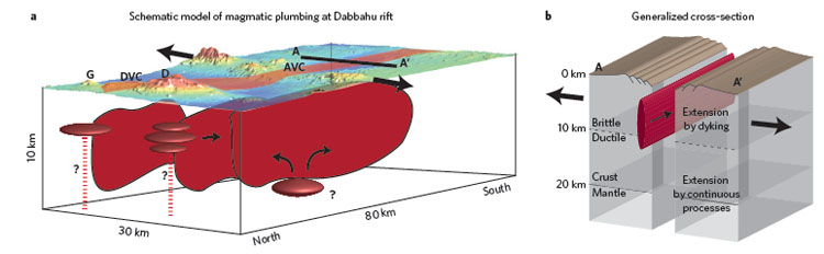
Figure 2: Conceptual model for slow-spreading ridges based on observations at subaerial spreading centres. a, Three-dimensional perspective of upper crust based on current understanding of the Dabbahu rift segment showing probable locations of magma chambers (dark red ellipsoids). Dykes are shown as red vertical planes. Topographic data are from the Shuttle Radar Topographic Mission at the zone of fissuring and faulting (highlighted in light red). Inferred hydraulic connections to deeper magma sources (red dashed lines). G, Gabho; DVC, Dabbahu Volcanic Centre; AVC, Ado 'Ale Volcanic Centre. b, Cross-section through typical slice of crust away from a magmatic centre. Dyke shown in red. Thin black arrows show magma flow direction; thick arrows show crustal extension direction.
Full paper (PDF file)